This second part of the article series focuses on navigating. The first focuses on aviating and provides basic fixes to flight data problems.
I’ve had a profound distrust of VOR navigation since 1993 when I found myself looking at a navigation signal that was somehow bent about 20 deg. to the south. I was flying a team of peacekeepers between two countries of the former Soviet Union aboard an Air Force Gulfstream III (C-20B) and it seemed there were no shortage of countries in the region that wanted our mission to fail. Our practice was to couple the navigation system to our laser ring gyro INSs displayed on the captain’s instruments, with any raw navigation signals displayed on the first officer’s side. I knew about “meaconing,” which the Defense Department defines as an enemy action to intercept and rebroadcast radio signals in an attempt to confuse an adversary, but I didn’t expect it. We were confused, but our INS, terrain charts and the clear skies kept us on course and away from those who wanted us to drift into enemy territory.
Of course, the accuracy of INS in those days was rather suspect. GPS changed everything, and it seemed that we ditched ground-based navigation aids almost overnight. So, nothing can go wrong now! Or can it?
The meaconing we worried about in a military context is only one part of the problem and GPS is not immune. The rest of the problem is known as “MIJI,” which stands for meaconing, intrusion, jamming and interference. We are often warned of GPS outages through NOTAMs with instructions to avoid certain chunks of airspace. This can be more than a navigation problem, however. In 2016, operators of Embraer Phenom 300 business jets were warned of potential problems with flight stability controls resulting from GPS interference.
Some international operations courses lightly touch on the subject of dead reckoning in the event of a complete loss of GPS, but I would bet few pilots know how to do it and some may not even be familiar with the term. If you don’t feel confident you can safely find the European continent after losing GPS halfway across the North Atlantic, you should brush up on your dead reckoning skills.
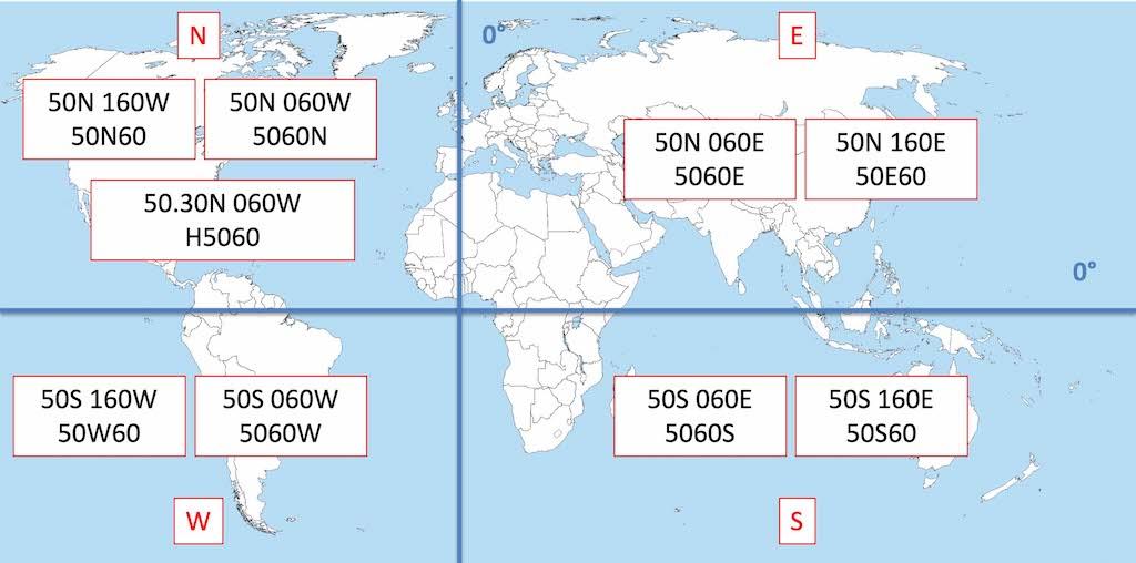
The navigation problem can be harder to detect than a faulty, jammed or missing GPS signal. It might be as simple as a flight management system (FMS) programming error that takes place outside your cockpit. When the North Atlantic Track System (NATS) adopted route spacing based on half degrees of latitude, the naming convention used by most FMSs changed. A part of the ARINC 424 specification used four numbers and a letter to pinpoint an oceanic waypoint. The position of the letter located the hemisphere of the coordinates. “5250N,” for example, means N 52°00’ W 50°00’. Moving the “N” changes everything so that “52N50” means N 52°00’ W 150°00’ on the other side of the world. When the NATS adopted half degrees of latitude, the ARINC 424 specification added a new place to put the “N” to denote the new position. “N5250,” for example, meant N 52°30’ W 50°00’. It was so subtle a change, however, that pilots immediately missed it and navigation errors along the NATS became more frequent. The solution that was adopted added the letter “H” to the mix. In our example, “H5250” means N 52°30’ W 50°00’.
Regardless of the source of confusion, we pilots need to arm ourselves against these kinds of data errors. As our airspace regions become more crowded, navigation accuracy is more than ever a matter of safety of flight.
(1) Apply oceanic planning techniques to all flights by comparing waypoints, estimated time en route, distances and fuel figures between the computed flight plan and the FMS.
(2) Check automatically produced takeoff and landing data (from the FMS, for example) with an independent source, such as AFM tables or a standalone application.
(3) Always keep the “big picture” in mind when looking at the route of flight shown on your navigation displays. For example, if a trip from Miami to New York includes a long leg heading west, you might have typed a waypoint incorrectly or it may have been coded incorrectly in the FMS database.
(4) Always keep the “close up” view in mind at each waypoint. Standard instrument departures, for example, often start in the wrong direction to blend in with other procedures. You should review those initial turns before takeoff.
(5) Let Air Traffic Control know if a GPS outage is creating flight anomalies you cannot otherwise explain. The 2016 issue with the Phenom 300 was a result of the aircraft’s yaw damper integration with GPS-reliant systems. Controllers may know of local military exercise activity and might be able to get your GPS signals back for you.
(6) Understand your aircraft procedures when dealing with unreliable or missing GPS signals. Your minimum equipment list may say you can under some conditions fly without GPS, but what are the procedures?
Part 3 focuses on communicating.

Related Content